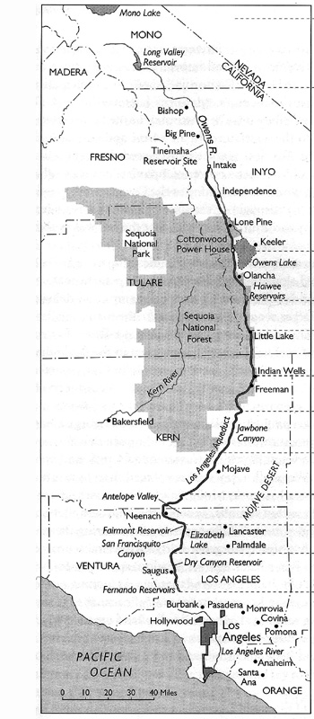
Completed in 1913, the first Los Angeles aqueduct spans an estimated 223
miles in length, tapping into the waters of the Owens River in central California.
The aqueduct was designed to support the continual development of Los Angeles
which had already began to outgrow its water resources.
In 1940 the aqueduct was extend 40 miles north to tap more water sources at
tributaries to Mono Lake. In 1970, having again out grown its water needs,
the city began construction of a second aqueduct doubling the amount of water
diverted from the Mono Basin and Owens Valley to Los Angeles.
The two Los Angeles Aqueducts now deliver an average of 430 million gallons
a day to the city. This photographic survey traces the los angeles aqueduct
from its origins at the mono lake to its entrance into the city.
Information on the los angeles aqueduct history can be found at the Los
Angeles Department of Water and Power,
A guide to the region can also be found at Owens
Valley Driving Guide by Kazys Varnelis.
Information on Mono Lake can be found at at www.monolake.org
Aqueduct map reproduced from: The First Los Angeles Aqueduct, circa 1908. Map published in "William Mulholland and the Rise of Los Angeles" by Catherine Mulholland, University of California Press, 2000.
all photographs © alan loomis 2004